Bring Visual Context to Your Assets.

A visual twin platform connecting engineering and operations through reality capture-based environments.

Who RealityTwin™ is For

EPCs & Reality Capture Providers

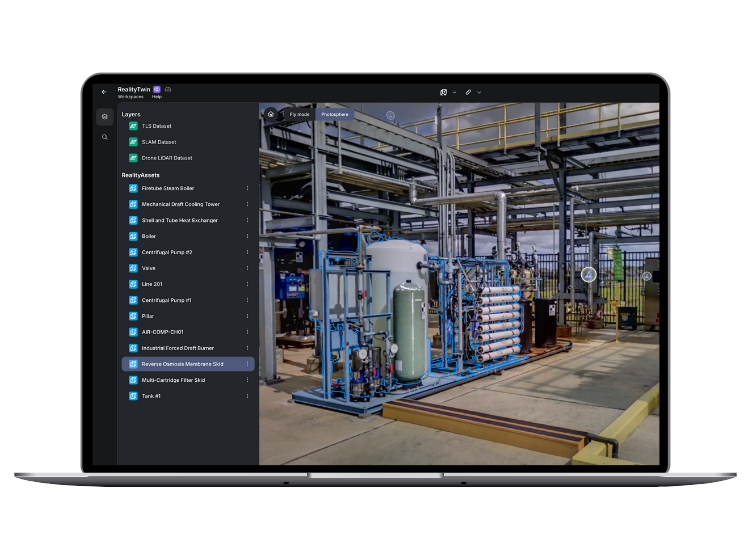
Quickly create and maintain accurate digital twins using your 3D scans.

  • Merge TLS, SLAM, drone or photogrammetry into one integrated model
  • Update only the changed areas—no rescan required
  • Prep and clean up scans for retrofits, shutdowns, or upgrades
  • Visual collaboration with clients made easy


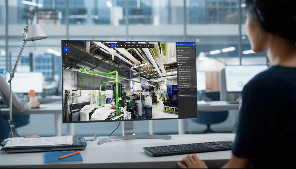
Ops & Maintenance Teams

Give every team member a visually accurate view of your facilities.

  • Seamless integration with ERP, MES, CMMS, IIoT
  • Access and manage assets remotely via interactive 3D views
  • Cut inspection times and increase on-site safety
  • Keep every site aligned with one visual source of truth


RealityTwin™ benefits at a glance

Over 90%

Less time spent in the field

Access and validate site conditions remotely through persistent, updated digital twins.

Up to 30%

Reduction in on-site inspection hours

Cut unnecessary site visits by maintaining a trusted visual reference of real-world conditions.

Enterprise

Ready & Connected

Integrates with SAP, Siemens, IBM Maximo, AVEVA, and AWS for data-driven decisions across maintenance and operations.

What is RealityTwin™?

Connect teams with actionable insights

Interactive 3D digital twin of an industrial facility displayed in Prevu3D's RealityTwin platform on a laptop screen

Connect teams with actionable insights

RealityTwin™ is a real-time, cloud-native platform that transforms 3D scan data into a visual environment. It empowers teams with a shared facility view, using spatial context and connected data to plan, execute, and optimize work effectively.

Built for:

  • Facility managers who need accurate, up-to-date site visibility.
  • Maintenance teams managing complex assets.
  • Operators accelerating digital transformation across sites.
Read More

Trusted by leading innovators in industrial operations

  • Saputo logo in grayscale
  • Agropur logo in grayscale with stylized drop icon
  • Can-Am logo with BRP gear emblem in black and silver
  • General Mills logo with heart symbol above stylized "G"
  • Amsted Rail logo with stylized rail track graphic
  • Olymel logo featuring a stylized fork within a circular badge and ribbon design

Manage a visual layer of your existing conditions

  • Combine all your 3D scanning data into a single visual environment

  • Easily update any area of your facility by layering new 3D scans

  • Clean up noise or artifacts in your 3D scanning data

Explore more

Transform static 3D scans into an interactive visual twin

  • Turn static 3D scans into a structured, interactive digital twin

  • Quickly isolate assets and make them selectable

  • Define information-rich asset metadata templates

  • Use the integrated search engine to quickly find what you need

Explore more

Connect all your enterprise systems of record

  • Enrich your visual assets by connecting various data systems

  • Link your systems of record — ERP, MES, CMMS, IIoT, and more

  • Manage secure data access with user-based permissions

Explore more

Navigate complex sites with ease in 3D

  • Interactively traverse spatial datasets within a high-fidelity 3D environment

  • Perform asset-level verification and location analysis in context

  • Remotely assess operational readiness and site conditions for planning and execution

Explore more

Why Choose Prevu3D

Tailored for Your Use Cases, Built for Real-World Impact

RealityTwin™ empowers your teams across the asset lifecycle, especially in operations and maintenance, by bringing clarity, speed, and collaboration to your most critical workflows.

Two engineers reviewing a 3D industrial scan on a desktop monitor using Prevu3D’s RealityPlatform software.

Virtual Tours & Remote Monitoring

Replace costly travel with up-to-date visual context. Give all your employees secure, remote access to current site conditions.

Discover

Professional using Prevu3D software on a laptop to analyze a color-mapped 3D model of an industrial facility

Site Condition Monitoring

Use updated 3D scans to track facility changes and ensure all stakeholders are working from the same visual reference.

Discover

Engineer in a 3D digital twin environment reviewing industrial equipment with Prevu3D annotations.

Operational Training & Safety Reviews

Use as-built environments to create immersive SOPs, document hazards, and reinforce safety, while reducing physical walkthrough risks.

Discover

Engineer viewing digital twin of piping systems on RealityPlatform interface

Asset Lifecycle Management

Track changes, sync metadata, and connect systems like CMMS and ERP for reliable, visual asset tracking.


Discover

What You Gain with RealityTwin™

  • Shared Site Awareness

    Give every team, from field techs to executives, a unified visual reference of your site to reduce delays, miscommunication, and redundant work.

  • Smarter Maintenance Coordination

    Enable faster troubleshooting and better planning with visual access to asset metadata, documentation, and site-wide context.

  • Seamless Collaboration Across Teams

    Operations, engineering, and contractors stay aligned using a persistent digital twin as their shared source of truth.

  • Device-Agnostic and Scalable

    RealityTwin™ supports a wide array of 3D capture formats, including photogrammetry, and is optimized for use across desktop, tablet, or mobile devices.


  • Future-Proof Asset Management

    Isolate, classify, and persist asset metadata even as scan sources evolve.
    Define it once. Use it forever.

    • Visually tag and manage equipment using RealityAssets™

    • Attach user-customizable templates (design, HSE, ops, etc.)

    • Enable persistent connections with systems like AVEVA PI and SAP

Planning a pilot or rollout? Let’s talk about the best approach.

Explore RealityTwin™ in Action

General Mills Digital Twin
Case study

General Mills Digital Twin

Read more
Visual Twin Deployment in Oil & Gas
Case study

Visual Twin Deployment in Oil & Gas

Read more
Food and Beverage Company Pilot Plant
Case study

Food and Beverage Company Pilot Plant

Read more

Frequently Asked Questions

  • Is RealityTwin™ compatible with my existing scans?

    Yes. RealityTwin™ supports LiDAR, SLAM, drone, and photogrammetry scans. You can align data using georeferencing (recommended) or with built-in manual alignment tools. Multi-source scans can be layered into a unified, navigable environment.

    See our supported scanners


  • Can we connect RealityTwin™ to our ERP or asset systems?

    Absolutely. With RealityConnect™, you can sync RealityTwin™ with SAP, IBM Maximo, AVEVA PI, AWS SiteWise, and other systems—enabling real-time data access and bidirectional metadata syncing at the asset level.

    For more information, contact our experts

  • How does pricing and licensing work?

    RealityTwin™ uses a flexible pricing model:

    • Storage-based: Pay for the volume of hosted and processed data (GB or TB)

    • User-based: Floating licenses allow multiple users to share access, only paying for the number of concurrent users

    • Role-based access: Free viewing for general users; licenses only apply to those authoring, editing, or managing data

    It’s designed for phased rollouts across divisions or sites—ideal for scaling without upfront lock-in.

    For more on pricing, contact our experts

  • Is RealityTwin™ usable by non-technical teams?

    Yes. RealityTwin™ includes a hybrid interface with both 3D mesh and photo-based views, allowing field techs, maintenance leads, and even executive stakeholders to explore and interact with the environment without needing CAD or scanning expertise.

    To get started, contact our experts

  • Can our contractors or scanning partners upload data directly to RealityTwin™?

    Yes. RealityTwin™ supports role-based access for external partners. You can assign upload permissions, require data formatting standards (e.g., meshable, georeferenced), and track deliverables per site or project. This ensures your data is usable from day one—without extra cleanup or back-and-forth.

Book a Demo

Experience Your Facility in Full Visual Context

Schedule a personalized walkthrough and explore how RealityTwin can transform the way your teams plan, operate, and collaborate—onsite or remotely.

With RealityTwin™, you can:

  • Eliminate time spent manually validating field conditions
  • Keep assets, documentation, and system data unified in one visual platform
  • Reduce surprises during shutdown execution and maintenance planning
  • Deliver the right data to the right people
  • Scale operational visibility across teams, sites, and systems

Talk to Our Team